


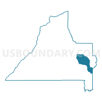
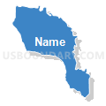
Herbert FD, Conecuh County, Alabama
About
Outline

Summary
| Unique Area Identifier | 521496 |
| Name | Herbert FD |
| County | Conecuh County |
| State | Alabama |
| Area (square miles) | 31.81 |
| Land Area (square miles) | 31.80 |
| Water Area (square miles) | 0.01 |
| % of Land Area | 99.97 |
| % of Water Area | 0.03 |
| Latitude of the Internal Point | 31.39059580 |
| Longtitude of the Internal Point | -86.76635540 |
Maps


Graphs
Select a template below for downloading or customizing gragh for Herbert FD, Conecuh County, Alabama


Neighbors
Neighoring Voting District (by Name) Neighboring Voting District on the Map
- Beat 8 FD, Conecuh County, AL
- Flat Rock Fire Dept., Conecuh County, AL
- Little Zion Church, Conecuh County, AL
- Loango, Covington County, AL
- Paul Fire Dept., Conecuh County, AL
Top 10 Neighboring County Subdivision (by Population) Neighboring County Subdivision on the Map
- Andalusia CCD, Covington County, AL (18,495)
- Evergreen CCD, Conecuh County, AL (5,762)
- Shreve CCD, Conecuh County, AL (676)
Top 10 Neighboring Unified School District (by Population) Neighboring Unified School District on the Map
Top 10 Neighboring State Legislative District Lower Chamber (by Population) Neighboring State Legislative District Lower Chamber on the Map
Top 10 Neighboring State Legislative District Upper Chamber (by Population) Neighboring State Legislative District Upper Chamber on the Map
- State Senate District 22, AL (137,373)
- State Senate District 31, AL (129,622)
- State Senate District 23, AL (111,939)